

Map 2026
1. General Information
- Local Self-Government Institution: Thalayolaparambu Grama Panchayat
- District: Kottayam
- Map Prepared By: Delimitation Commission, Kerala
- Date: 15-10-2025
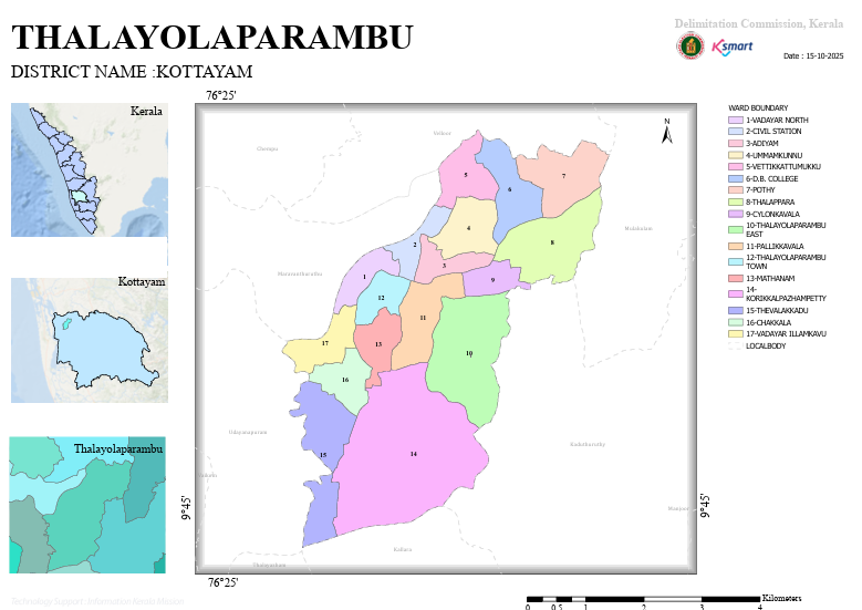
- The map clearly depicts the Panchayat ward boundaries and the adjoining local bodies.
2. Geographical Location
Thalayolaparambu Grama Panchayat is one of the major Grama Panchayats in Vaikom Taluk. The Panchayat shares its boundaries with the following Local Self-Government Institutions:
- Kaduthuruthy
- Manjoor
- Chempu
- Udayanapuram
- Kallara
- Maravanthuruthu
- Velloor
- Thalayazham
- Mulakulam
- Vaikom
This highlights the Panchayat's strategic central location and its strong connectivity with the surrounding Panchayats.
3. Ward Structure
The Panchayat consists of a total of 17 wards:
| Ward No. | Ward Name |
|---|---|
| 1 | Vadayar North |
| 2 | Civil Station |
| 3 | Adiyam |
| 4 | Ummamkunnu |
| 5 | Vettikkattumukku |
| 6 | D.B. College |
| 7 | Pothi |
| 8 | Thalappara |
| 9 | Ceylon Kavala |
| 10 | Thalayolaparambu East |
| 11 | Pallikkavala |
| 12 | Thalayolaparambu Town |
| 13 | Madhanam |
| 14 | Korikkal Pazhambetty |
| 15 | Thevalakkad |
| 16 | Chakkala |
| 17 | Vadayar Illamkavu |
4. Developmental Observations
- Ward 12 (Thalayolaparambu Town) appears to function as the Panchayat's primary commercial and service centre, as indicated by its ward name.
- Civil Station Ward and D.B. College Ward indicate the presence of important administrative and educational institutions within the Panchayat.
- Areas such as Vadayar, Pallikkavala, and Ceylon Kavala are likely to serve as key transportation and commercial hubs.
- The ward layout reflects a balanced combination of an urbanized central area and surrounding rural regions.
5. Conclusion
Thalayolaparambu Grama Panchayat comprises 17 wards and is a significant Local Self-Government Institution that integrates education, commerce, public administration, and rural development. Its strategic central location and strong geographical connectivity with neighbouring Panchayats enhance its development potential. The ward delimitation map demonstrates a well-planned administrative structure designed to ensure effective governance and equitable public representation.